Navigation & Positioning
Mastering Celestial Navigation Techniques for Mariners
Explore the essential celestial navigation techniques that empower sailors with accurate positioning using celestial bodies. Enhance your maritime skills today!
Key takeaways
- Explore the essential celestial navigation techniques that empower sailors with accurate positioning using celestial bodies. Enhance your maritime skills today!
- Understanding Celestial Navigation Techniques for Mariners
- What is Celestial Navigation?
- The Importance of Celestial Navigation
Article topic
Navigation & Positioning
Explore the essential celestial navigation techniques that empower sailors with accurate positioning using celestial bodies. Enhance your maritime skills today!
Understanding Celestial Navigation Techniques for Mariners
Celestial navigation is a fundamental skill for sailors, allowing them to determine their position on Earth using celestial bodies. Despite the rise of GPS navigation systems, a solid foundation in celestial techniques remains crucial. This article details the principles, instruments, and methods involved in celestial navigation, beneficial for sailors of all levels.
Key Takeaways
- Celestial navigation utilizes the positions of stars, planets, and the sun to ascertain location.
- Essential tools include a sextant, chronometer, and nautical almanac.
- Regular practice and understanding of weather conditions enhance accuracy.
What is Celestial Navigation?
Celestial navigation involves using celestial bodies—such as the sun, moon, and stars—to find one’s position. By measuring the angles between these bodies and the horizon, sailors can calculate their latitude and longitude.
The Importance of Celestial Navigation
- Backup to Modern Technology: GPS is reliable but can fail; celestial navigation offers a dependable alternative.
- Enhanced Understanding: It deepens knowledge of the Earth's movements and improves overall navigational skills.
- Cultural Legacy: Learning celestial navigation connects sailors to a rich maritime heritage.
Essential Instruments for Celestial Navigation
To perform celestial navigation effectively, sailors need specific instruments:
Sextant
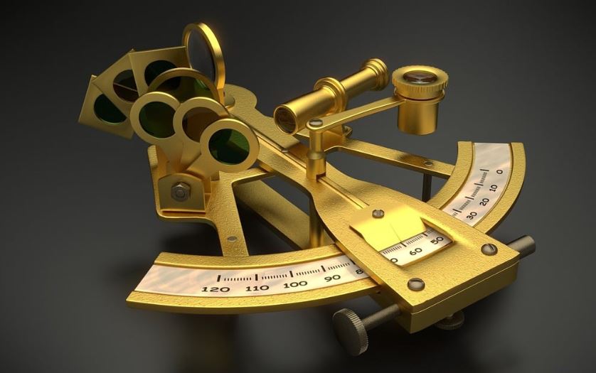
The sextant is essential for measuring angles between celestial bodies and the horizon. Here’s how to use it:
- Align the index arm with the horizon, ensuring the celestial body is in view.
- Adjust until the reflected image aligns with the horizon.
- Record the angle for further calculations.
Chronometer
Accurate timekeeping is crucial. A chronometer tracks local time, which is needed to relate celestial measurements to the time at a known location.
Nautical Almanac
This provides data on celestial bodies throughout the year, helping sailors correlate their measurements with known positions.
Calculating Your Position
Follow these steps to calculate your position:
- Take Sightings: Use the sextant to measure celestial bodies.
- Record Time: Note the time of each measurement using the chronometer.
- Consult the Nautical Almanac: Cross-reference your sightings with the almanac.
- Calculate Latitude: For example, during solar noon, the sun’s zenith gives your latitude directly.
- Compute Longitude: Find the time difference (UT) between local noon and GMT and use the formula:
Longitude = (Local Time - GMT) × 15° 6. Plot Your Position: Use a nautical chart to visualize your determined latitude and longitude.
Practical Tips for Successful Navigation
- Regular Practice: Frequent use of celestial navigation techniques will enhance your skills.
- Instrument Check: Always calibrate and check your sextant and chronometer before use.
- Reference Chart: Familiarize with key stars and their coordinates.
- Weather Awareness: Celestial navigation requires clear skies; choose optimal conditions.
Safety Reminders
- Account for Errors: Be mindful of measurement inaccuracies; take multiple readings for precision.
- Know Your Environment: Celestial navigation may be unsuitable during severe weather; know your limitations.
- Familiarity with Instruments: Invest time in mastering your sextant and other tools to ensure confidence while navigating.
FAQ
What is celestial navigation?
Celestial navigation is the method of determining your position on Earth by measuring the angles between celestial bodies and the horizon.
What instruments do I need for celestial navigation?
You require a sextant, a chronometer, and a nautical almanac.
Is celestial navigation still relevant today?
Yes, it serves as a reliable backup and enhances overall navigational skills, even as technology evolves.
Final Summary
Celestial navigation remains a critical skill for modern sailors, combining traditional techniques with practical application. Mastering these techniques not only ensures safer voyages but also fosters appreciation for sailing's rich history. Whether you're a novice or seasoned mariner, understanding celestial techniques can broaden your navigational toolkit, enriching your sailing experience.
By applying these principles and regularly practicing, you will bolster your confidence on the water, equipped with the knowledge that should GPS fail, you can rely on the stars to find your way.
Practical skipper examples: Add real-world sailing examples that make Mastering Celestial Navigation Techniques for Mariners more actionable.
Consider a mid-ocean passage from the Canary Islands to the Caribbean. As a skipper, you are four days out, and your primary GPS plotter flickers—a common failure due to saltwater intrusion in the cockpit unit. You now rely on your dead reckoning (DR) log and celestial fixes to maintain your confidence. You decide to take a morning sun sight to verify your position.
The routine begins with a "running fix." At 0900 UTC, you take your first solar observation, recording the sextant altitude and the exact chronometer time. You plot this Line of Position (LOP) on your paper chart. Because you are moving, this line is just one component of your final fix. You continue on your heading, maintaining a strict watch on your speed through the water.
By 1200 UTC, the sun reaches its local apparent noon (LAN). You stand on deck with your sextant, anticipating the maximum altitude. As the sun begins to "dip" or stop rising, you lock in the peak measurement. This gives you a precise latitude. By intersecting this latitude line with your projected 0900 LOP, you have successfully verified your position without any electronic aid.
Another scenario involves night-time navigation near a shipping lane. You have identified three bright stars: Sirius, Rigel, and Betelgeuse. By measuring the altitude of each in quick succession, you create a "triangle of uncertainty" on your plotting sheet. If the lines converge within a small three-mile radius, you know your position is solid. This visual triangulation is a powerful tool to confirm that your DR position is accurate before entering busy coastal waters where depth might be an issue.
For the solo sailor, consider the "noon sight" as a daily ritual. Even if your electronics are working perfectly, taking a noon sight keeps your eyes tuned to the horizon. One afternoon, you notice your calculated position is consistently five miles west of your GPS. By investigating, you realize your current set and drift have increased due to a Gulf Stream eddy. The celestial sight provided the "ground truth" that the digital display masked.
Finally, imagine navigating through a patch of fog that hasn't lifted for 48 hours. You are concerned about your distance from a rocky coastline. Using a moon sight—even in overcast conditions—can provide a rough position LOP. If you can catch even a fleeting glimpse of the moon through a break in the clouds, that single LOP tells you how far you are from a danger zone. These actions are not just academic; they are the difference between a controlled arrival and a panicked emergency. By integrating these small, intentional moments into your daily voyage, you transition from a passenger of technology to a true master of your vessel’s destiny.
Detailed checklist for safe use: Add a deeper checklist with planning, underway, and post-use checks.
Reliable celestial navigation demands rigorous preparation. Use this structured checklist to ensure your procedures are consistent and error-free.
Pre-Voyage Planning:
- Verify your Nautical Almanac is the current year’s edition.
- Confirm your watch or digital chronometer is synchronized to UTC to within one second.
- Check the battery life of your secondary timing device.
- Ensure your plotting sheets are clean, dry, and protected from dampness.
- Verify the sextant's index error is recorded and that the mirror is free of salt spray.
- Keep a dedicated celestial logbook with columns for date, time, object, altitude, and corrected LOP.
Underway Execution:
- Perform a "dry run" with your sextant in a safe, static location on the boat.
- Ensure you are wearing non-slip footwear before climbing to the cockpit for a sight.
- Keep the horizon clear; ensure your view isn't obstructed by sails or rigging.
- When sighting, maintain a stable stance—use the "kneel and brace" technique against a bulkhead.
- Take at least three rapid-fire readings and average them to minimize human error.
- Double-check your arithmetic; transcribe raw data immediately to avoid memory lapses.
- Always draw the LOP on the chart with the time and the celestial body noted clearly.
Post-Use Maintenance and Storage:
- Gently wipe the sextant mirrors with a lint-free lens cloth—never use abrasive paper.
- Apply a light coating of protective oil to the worm gear and index arm.
- Secure the instrument in its padded case immediately after use to prevent accidental drops.
- Close your almanac and secure it in a dry, waterproof bag.
- Review your calculated position against your DR. If there is a major discrepancy, re-calculate before committing to a course change.
- Clean the lens of your binoculars, as they are often used to identify stars before sextant work.
This checklist serves as a buffer against complacency. Even in calm seas, skipping a step—such as forgetting to note the index error—can introduce a fatal mile of drift. Treat these steps as a mandatory protocol, much like checking the engine oil before departure. By standardizing your routine, you reduce the mental load during high-stress situations. Remember that accuracy is built on the foundation of boring, repetitive diligence. If the weather changes rapidly, having your tools ready and your data organized means you can move from observation to decision-making in minutes rather than hours. Safe navigation is a sequence of small, verified truths.
Troubleshooting and common mistakes: Add mistakes, warning signs, and correction steps that improve practical value.
Even seasoned navigators encounter hurdles. Identifying errors early is the hallmark of a skilled mariner.
Common Mistake 1: The "Horizon Error." Beginners often mistake a dark cloud bank on the horizon for the actual horizon line. If the sun is sitting on a cloud bank rather than the true sea horizon, your altitude measurement will be significantly skewed, resulting in a position error of several miles.
Correction: Use a wide-angle search to confirm the horizon line is continuous. If in doubt, wait for the sun to clear the obscuration.
Common Mistake 2: Clock Error. Using the wrong time zone or failing to account for leap seconds can throw your longitude calculations off by tens of miles.
Correction: Develop a habit of writing "UTC" next to every time entry. Verify your watch against a reliable time signal (like a GPS readout or a shortwave radio broadcast) every morning.
Common Mistake 3: Index Error Ignorance. Over time, the sextant’s mirrors can shift due to temperature changes or light vibrations. If you don't check for this, your measurements will have a constant, creeping bias.
Correction: Every time you take a sight, perform a quick check by aligning the horizon with its reflection. If they don't meet, note the difference and apply it as a correction to your math.
Common Mistake 4: Mathematical Fatigue. Celestial math is precise. A simple transposition error (writing 45 instead of 54) will ruin the result.
Correction: Work in pencil. Perform your calculations twice. If the result doesn't make sense (e.g., you seem to be in the middle of a desert when you’re in the Atlantic), stop. Re-verify your DR position; the error is almost certainly in your math, not your location.
Warning Signs:
- If your LOPs do not intersect within a reasonable distance, your data is compromised.
- If the movement of the sun seems to defy your expected path, you have likely misidentified the body or inverted your math.
- Watch for "Instrument Drift," where the sextant becomes harder to manipulate due to stiffness; this indicates internal corrosion or grit that needs immediate cleaning.
Correction Steps:
- When a fix fails to align, revert to your last known good position.
- Restart your calculations from the raw sextant data.
- If you still cannot resolve the discrepancy, ignore the bad data point. Never "force" an LOP to fit your desired path; accept the error and move to the next observation. Being honest about your uncertainty is safer than relying on a manufactured fix. Troubleshooting is not a sign of failure; it is a critical part of the navigation process that ensures you remain grounded in reality.
Final safety summary: Add a concise but useful safety-focused summary and next steps.
Mastering celestial navigation is an ongoing process of refining your relationship with the environment. At its core, safety in navigation relies on redundancy. The goal of learning these techniques is not to replace your electronic systems, but to provide a robust, reliable backup that functions regardless of power supply, satellite availability, or hardware failure.
To maintain your proficiency, consider the "One-Sight-a-Month" rule. Whether you are coastal cruising or sitting at home, take a sun sight periodically. This keeps your manual dexterity sharp and your mathematical recall fluid. If you find your skills slipping, revisit your reference charts and practice the basic sight reduction process until it feels intuitive.
Remember that navigation is a decision-making tool. The purpose of a fix is to provide the data required to avoid hazards. If you are ever unsure of your position, the safest course of action is always to slow down, increase your distance from known dangers, and broaden your margin of error. Celestial navigation provides a "sanity check" for your electronic data. If the two sources disagree, prioritize the one that doesn't require electricity, as it is the most resilient in the face of catastrophic system failure.
As you move forward, expand your library. Seek out specialized texts on "sight reduction tables" to simplify the complex math. Join local sailing forums or coastal navigation groups where you can practice with peers. The true value of this skill is the confidence it instills. When you are offshore, looking at the stars, you will no longer see just points of light; you will see a map. You will understand that your position is not merely a number on a screen, but a place held in space by the celestial bodies above you.
Keep your equipment clean, your logbooks updated, and your horizon clear. The ocean is vast and unforgiving, but with the right techniques and a disciplined approach, you are never truly lost. Your next step is to head out on your next passage with a renewed commitment to these analog foundations. Rely on your instruments, trust your eyes, and keep your primary goal in sight: a safe, confident, and independent voyage to your next destination. Always prioritize situational awareness over convenience, and ensure that every member of your crew knows at least the basics of how to read the sky. Safe travels, and may your horizons always be clear.
Imagine you are mid-ocean, three days out of the Azores, with a failing GPS display. You transition to your "Plan B." You perform a morning sun line sight to establish a line of position (LOP). By marking the exact time of the transit, you calculate your latitude. Later, at twilight, you identify Venus and Polaris. By crossing the sun line from earlier with the star sights, you create a "running fix." This intersection provides a coordinate box within five nautical miles of your dead reckoning position, giving you the confidence to maintain your current heading toward the archipelago.
Alternatively, consider a passage through the doldrums where heavy cloud cover persists. You seize a momentary break in the clouds at local apparent noon to capture the sun’s meridian passage. Even if you cannot get a formal fix, this meridian altitude provides an absolute latitude. Recording this in your logbook ensures that if your electrical system dies, you aren't guessing your north-south position. These moments prove that celestial navigation is not just an emergency skill; it is a grounding practice that links your vessel to the geometry of the planet.
To master the art of position fixing, maintain a rigorous procedural workflow. This ensures that no step is forgotten during high-stress situations.
Phase 1: Pre-Voyage Planning
- Almanac Review: Verify your nautical almanac is current for the specific year of your voyage.
- Chronometer Sync: Synchronize your primary timepiece to UTC (GMT) using a reliable radio time signal. Record the error in your log.
- Equipment Inspection: Inspect the sextant mirrors for silvering degradation and ensure the index arm swings smoothly.
- Sight Planning: Use star-finding software or prep sheets to identify which bodies will be visible during nautical twilight.
Phase 2: Underway Execution
- Horizon Verification: Scan for localized haze or swells that may distort the apparent horizon before committing to a sight.
- The "Three-Sight Rule": Always take at least three sights of the same body in rapid succession. Average them to mitigate human error in timing or reading.
- Immediate Logging: Record the time, the altitude, and the body name immediately upon completion. Do not trust your memory.
Phase 3: Post-Use Maintenance
- Cleaning: Use a soft, non-abrasive lens cloth to remove salt spray from mirrors and the telescope.
- Secure Stowage: Place the sextant in its case, ensuring the index arm is locked in a neutral position to prevent impact damage.
- Data Verification: Cross-reference your manual plot against your secondary navigation methods (DR or AIS) to identify drift or calculation discrepancies.
Advanced Sight Reduction: Navigating Without Modern Computers
While electronic calculators have replaced traditional logbooks for many, understanding the "Old School" method of sight reduction is essential for true mariner independence. The process involves converting a measured altitude into a geographical position (GP) on the Earth’s surface.
Begin by calculating the Observed Altitude (Ho). This requires adjusting your Sextant Altitude (Hs) for index error, dip, refraction, and semi-diameter. Once the Ho is established, refer to the Nautical Almanac to find the Greenwich Hour Angle (GHA) and Declination (Dec) of the body at your specific time of observation. Using the intercept method (Marcq St. Hilaire), you compare your calculated altitude (Hc) with your observed altitude (Ho). The difference determines how many miles you are toward or away from the body's GP.
Practice this calculation in port during clear weather. If you can perform the math on a calm dock, you will be able to do it under pressure. Maintain a clear, step-by-step worksheet to prevent cumulative arithmetic errors. Remember, every digit counts; a transposition error of a single degree can displace your fix by sixty nautical miles.
The Psychology of Celestial Navigation: Maintaining Focus
Celestial navigation requires a distinct mindset compared to staring at a chart plotter. It demands patience and an acceptance of the environment. Unlike the instant gratification of GPS, celestial sights are retrospective—you are measuring where you were, not necessarily where you are this exact second.
To maintain focus, adopt a "watch-leader" mentality. Allocate specific times for sights, such as morning and evening twilight. Do not become obsessed with obtaining a perfect fix every hour; instead, focus on the consistency of your observations over several days.
If you find yourself becoming frustrated, step away. An irritated navigator is prone to transcription errors. Acknowledge that the sky is a complex system that moves at its own pace. By integrating celestial observations into your daily sailing rhythm, you transform a chore into a meditative practice. This psychological preparation is as vital as the accuracy of your sextant. Trust the math, respect the environment, and always keep a backup pencil sharpened.
Integration with Dead Reckoning (DR)
Never treat celestial navigation as a standalone island. It must be woven into your broader Dead Reckoning (DR) framework. Your DR position serves as the foundation upon which your celestial fixes are anchored. If your celestial fix appears to be 50 miles away from your DR position, do not automatically assume the fix is right. Check your log for current set and drift, steering errors, or improper speed estimates.
The synergy between DR and celestial navigation is the hallmark of an experienced skipper. Use DR to project your position forward between twilight windows. When you capture a celestial fix, use that result to update your DR starting point. This cyclical process ensures that even if you miss a window due to cloud cover, your estimated position remains reasonably accurate.
If the celestial fix deviates significantly from your DR, look for the "Why." Did you hit an unexpected current? Is the compass deviation changing? Celestial navigation acts as a reality check for your senses, forcing you to constantly refine your internal model of the vessel’s progress through the water.
Meteorological Impacts on Accuracy
The atmosphere is not a vacuum, and light behaves differently depending on the conditions. Temperature inversions, common in mid-latitude sailing, can cause atmospheric refraction that bends light differently than standard tables predict. If you notice the horizon appearing unusually sharp or "lofted," be wary of your altitude readings.
Humidity and air pressure also play roles in the precision of your sight. During periods of high pressure, air density changes slightly, impacting the refraction correction values. While usually negligible for general navigation, high-latitude sailing requires extra caution. Near the poles, the sun stays lower in the sky, meaning light passes through a greater thickness of the atmosphere, increasing refraction errors significantly.
Always include a weather observation in your navigation log alongside your celestial data. Note the barometric pressure, air temperature, and visibility. Over months of logs, you will begin to see patterns in how your specific sextant and the local environment interact, allowing you to "calibrate" your eye to the nuances of the sky under varying conditions.
Building a Personal Navigation Library
To become a master, move beyond the basic manuals. A comprehensive navigation library is an invaluable resource for the serious mariner. Start by acquiring a copy of Bowditch’s American Practical Navigator, often referred to as the "Sailor’s Bible." Its depth of information on mathematics and celestial mechanics is unmatched.
In addition to reference texts, maintain a dedicated "Navigator’s Journal." This should be distinct from the ship’s official log. Use this journal to store your practice sights, worked examples, and any discovered "tricks of the trade." Include sketches of constellation patterns, notes on the star magnitudes you find easiest to identify, and observations on how different sextant filters perform in various lighting conditions.
Over time, this journal becomes a personalized masterclass in your own development. When you encounter a challenging navigation scenario, flipping back through your own notes is often more helpful than consulting a generic textbook. It reminds you of how you solved problems in the past and builds the confidence necessary to handle the unknowns of the future.
Conclusion: The Endurance of Celestial Skills
Mastering celestial navigation is an investment in self-reliance. It is the ability to look up at the heavens and know your place on the vast, featureless blue of the ocean. While technology will continue to advance, the stars remain fixed, reliable, and accessible to anyone with the curiosity to learn. By practicing these techniques, keeping your gear maintained, and refining your methodology, you elevate yourself from a passenger of technology to a true navigator of the seas. Continue your training, stay curious, and let the stars guide your passage.
Frequently asked questions
Celestial navigation is the technique of using celestial bodies to determine one's position on Earth.
Comments coming soon
We’re preparing a community discussion area for every learning article.
Related articles
Read More
Continue with related sailing guides and topic pages to build a stronger understanding before your next passage.
AI route planning mistakes sailors should avoid
7 AI Route Planning Mistakes Sailors Must Avoid in Modern Navigation
Discover the critical pitfalls of relying solely on AI for nautical route planning. Learn how to balance technology with traditional seamanship for safer voyages.
Read MoreNavigation & Positioning
Autopilot Systems for Yachts: Essential Guide for Sailors
Explore the key features and benefits of yacht autopilot systems. Enhance safety and comfort on your voyages with this comprehensive guide.
Read Morecoastal-navigation
Basic Coastal Navigation for New Sailors
A beginner-friendly coastal navigation guide covering charts, position checks, bearings, waypoints, hazards, and pilotage planning.
Read MoreNavigation & Positioning
Explore more in Navigation & Positioning
Charts, bearings, GPS, coordinates, passage awareness, and position checks.
Read MoreLearning Center
Browse the Learning Center
Find navigation, weather, seamanship, safety, and marina planning articles.
Read More